Posts

Showing posts with the label Great Lakes storm

Picture This: Autumn Rolling In

Image
Autumn Rolling In (Muskegon, MI)

Picture This: Storm Warning

Image
Storm Warning ( by K. Walters, Grand Haven, MI) NOAA & the National Weather Service are forecasting a storm warning for the next couple of days on Lake Michigan: THIS STORM WARNING IS IN EFFECT FROM 1 PM THURSDAY TO 4 PM CST FRIDAY. THE STORM WATCH IS NO LONGER IN EFFECT. * WINDS...NORTH TO NORTHWEST STORM FORCE TO 55 KT . * SIGNIFICANT WAVES...TO 25 FT. * OCCASIONAL WAVES...TO 33 FT. PRECAUTIONARY/PREPAREDNESS ACTIONS... A STORM WARNING MEANS WINDS OF 48 TO 63 KNOTS ARE IMMINENT OR OCCURRING. RECREATIONAL BOATERS SHOULD REMAIN IN PORT...OR TAKE SHELTER UNTIL WINDS AND WAVES SUBSIDE. COMMERCIAL VESSELS SHOULD PREPARE FOR VERY STRONG WINDS AND DANGEROUS SEA CONDITIONS...AND CONSIDER REMAINING IN PORT OR TAKING SHELTER IN PORT UNTIL WINDS AND WAVES SUBSIDE.

Fall Storms on Lake Michigan

Image
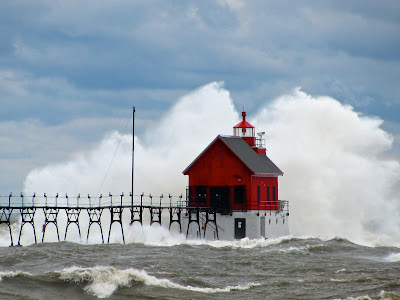
Just thought I'd make a quick post to share the stormy fall season on the Great Lakes and specifically Lake Michigan. Back on September 28, 2009 we had a major storm come ashore in Grand Haven. The NOAA forecast called for a storm warning with 50kt+ winds and 15-20 foot waves. I don't know the actual wave heights or the wind speeds that day, but I can say that I've never seen more wind or bigger waves on Lake Michigan than I did that day. Check these videos for a better description than words can provide: And lastly, 20 degrees of heel in the slip: