
Escape to the Sea: How to get from the Great Lakes to the Caribbean
Let's say winter's chill was something you could no longer take as a
Great Lakes sailor. Or perhaps you just want to extend your sailing season
beyond the boundaries of summer. What options do you have? You could
just opt for a bareboat charter somewhere in the Caribbean and consider
the itch scratched. But then you'd miss out on all the adventure of moving
a boat between the Great Lakes and the Caribbean. And you wouldn't be
sailing your boat. I'm here to convince you that the best option is to sail your own
boat south. What follows is an overview of the route you could take to get
you and your boat to warmer water and weather from the Great Lakes.
Route 1: St. Lawrence Seaway (including Lake Champlain shortcut)
You're adventurous if you choose this route. From most starting locations
in the Great Lakes, you'll also be seeing the most scenery and passing the
most water beneath your keel. Some of the most beautiful natural coastline
anywhere in the world can be found in the northeast Canadian provinces and
along the coast of Maine, which are all potentially part of this route.
Additionally, you'll pass through the picturesque Thousand Islands area of
Ontario as you exit Lake Ontario and head towards Montreal. Because of the
extra mileage required when taking this route, it's generally advisable to
get an early start (~July 1 or sooner). Another advantage is being able to
leave your mast up for the entire route. The other routes will require you
to un-step and step the mast at least once.
The St. Lawrence Seaway is actually a series of locks, canals and rivers
that connect the Great Lakes to the Atlantic Ocean. Officially, the seaway
extends from Montreal to Lake Erie and includes the Welland Canal. The
route also includes 15 total locks. There's a minimum vessel size
requirement of 20 feet and 1 ton to transit the seaway. More than 2,000
recreational pleasure craft pass through the seaway each season and as
such, there area special docks and tie-up areas along the seaway for
overnight stays and extended stops. Seaway staff are often available to
help with tie-ups and locking through. Be sure to bring good fenders
and/or fender boards to protect your boat from the cement lock
walls.
Be aware that commercial traffic takes priority on the seaway and
pleasure craft will often be asked to wait while commercial vessels pass
through various locks. You'll also need to be aware of up-bound (from the
Atlantic) and down-bound (toward the Atlantic) shipping lanes. Once you
reach Montreal, the St. Lawrence River will take you past Quebec and out
to the Gulf of St. Lawrence where you can explore Newfoundland, Labrador
and New Brunswick if your interest and time allow. The St Lawrence
River and Gulf of St. Lawrence are not for the inexperienced, as the
extreme tides and currents can make navigation challenging. In fact, the
Bay of Fundy inside of Nova Scotia has the highest tidal range in the
world with a mean spring range of 47.5 feet. That's right, the water level
can rise or fall up to 47.5' in just 12 hours! If leaving the Great Lakes,
the current in the St. Lawrence River will be your friend, but coming home
on this route can be an upstream battle.
Lake Champlain shortcut: Take the Richelieu River from its
confluence with the St. Lawrence River at Sorel-Tracy, Quebec (downstream
from Montreal) to Lake Champlain and then follow the Hudson River from the
southern end of Lake Champlain through Albany to New York City. This
bypasses most of the St. Lawrence River and the entire Gulf of St.
Lawrence in favor of a quick trip through New York state ending at the
feet of Lady Liberty.
Congratulations, you made it to the Atlantic Ocean! Now point the bow
south and start making some headway towards warmer water. You've still got
options. The most popular is to catch the Intracoastal Waterway (ICW) and
head south to Florida before making your jump across the Gulf Stream. Or
you can pick one of many jump-off spots to begin a blue water passage from
the east coast of the U.S. direct to the Virgin Islands. Or perhaps a
mid-passage stop-over in Bermuda is more your flavor. In any case, you're
now in saltwater and have the world sprawled before your bow.
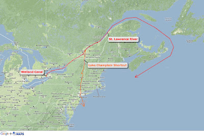
|
| Route 1: St. Lawrence Seaway (click the picture for a larger view) |
Pros:
- Scenery (Gulf of St. Lawrence, ect.)
- Mast stays up
- Potential for more sailing
Cons:
- Longest route
- Difficult navigation (currents, open water, extreme
tides)
- Few services beyond Quebec City
Summary: A great route if you've got time, experience and an adventurous spirit.
Additional information for this route
-
For more detailed information about transiting the St. Lawrence Seaway, visit: Pleasure Craft Guide to the St. Lawrence Seaway
-
To read the blog of a vessel that chose this route: Log of s/v Precipice
-
Cruising guides:
Route 2: Erie Canal (including Trent-Severn Waterway, Welland and
Oswego Canals)
This is likely the most popular and/or common route from the Great Lakes to
the open ocean. Know that you'll need to take the mast down to transit the
Erie Canal at a rate of about $4-$8 per foot of mast. There are decent
boatyards at both ends experienced in helping cruisers unstep and step their
masts. Remember to be prepared with a means of carrying and supporting your
mast on deck when it's down.
There are also at least a few variations to consider within this route.
Your first decision point will have to be made somewhere in Lake Huron (if
you're coming from the Upper Great Lakes). You can either make your way to
the far southern end of Lake Huron and follow the St. Clair River into Lake
St. Clair and on south through the Detroit River into Lake Erie, or take the
Trent-Severn Waterway south out of Georgian Bay on Lake Huron through
Ontario's "cottage country", including Lake Simcoe, and on through a series
of locks to northern Lake Ontario. The latter route bypasses Detroit and all
of Lake Erie and affords nice side trips through Lake Huron's North Channel
and Parry Sound, both of which are legendary in the sweet water cruising
world.
If you find yourself in Lake Erie, either by way of the Detroit River or
because your homeport is there, you'll need to decide if you want to pick up
the Erie Canal in Buffalo at the far eastern end of the lake, or if you
prefer to transit the Welland Canal into Lake Ontario and make an eastward
run to the Oswergo Canal in Oswego, New York. The Oswego Canal will take you
about 24 miles south and meet up with the Erie Canal near Three Rivers and
Liverpool.
At this point, all variations converge back on the Erie Canal near
Liverpool, New York (outside of Syracuse) and are ready to continue the
eastward voyage through the rest of the canal all the way to Albany. When
you reach Albany, the trip will change and you'll leave the Erie Canal
behind and head due south on the Hudson River all the way to New York
Harbor. As a nice yin to the wilderness yang of the Gulf of St. Lawrence
described in the first route above, the New York skyline and all of
Manhattan will be on your port beam as you finally exit the Hudson River.
Congratulations, you've made it to saltwater! See the continuing routes to
the Caribbean described in the first route.

|
| Route 2: Erie Canal (click picture for a larger view) |
Pros:
- Popular, well-worn path
- Lots of good services for rigging/stepping
- Potentially fastest route to the Caribbean
Cons:
- Mast must come down
- Lots of motoring
- Potential canal/lock closures
Summary: This is likely the most common route from the Great Lakes to the ocean, so services and guides are plentiful.
Additional information for this route
-
To read the blog of a vessel that chose this route: Log of s/v Rasmus (Windtraveler)
Route 3: Mississippi River (including Ten-Tom Waterway)
This third option for exiting the Great Lakes and
making your way to saltwater may not sound as enticing, but there are some
perks, so read on! You’ll essentially be completing the western
portion of the Great Loop as
you exit southern Lake Michigan at Chicago via the
Chicago River and shortly thereafter the
Des Plaines River . This is a downstream run,
so while your mast won’t be up, your iron genny will still get some help
from Mother Nature. As you meander past
Peoria St. Louis ,
Missouri Memphis , Tennessee and on
through
Greenville ,
Mississippi New Orleans ,
Louisiana
If your homeport is on Lake Michigan or your ultimate destination is
somewhere in the Gulf of Mexico or (lucky you!) the Pacific Ocean via the
Panama Canal, heading down the
Mississippi Chicago Florida

|
| Route 3: Mississippi River (click the picture for a larger view) |
Pros:
- Good option from Lake Michigan
- Ten-Tom Waterway is enjoyable
- Easy access to Gulf of Mexico and Florida Keys
Cons:
- Mast must come down
- Lots of motoring
- Lots of commercial traffic and monotonous stretches of
river
Summary: This route can save time/distance if you're in the western Great
Lakes or if you've already cruised the east coast and ICW.
- The Looper's Companion Guide: Cruising America's Great Loop
- Tennesee Tombigbee Waterway (Official site)
- To read the blog of a vessel that chose this route: Log of s/v Mariposa
Editor's Note: If you've completed any of the above routes, I'd love to hear your opinion and any additional details and tips you may have. While I personally haven't completed these routes, I plan to make an effort someday and have been researching them for a couple of years now.
A good overview, but I would contend that the Maritimes have plenty of technical help past Quebec City, but that it's just orientated toward the fishing fleets. Certainly by PEI/Cape Breton Island, there is plenty of places to get things fixed. The north side of the river past Quebec City does get a little wild, however.
ReplyDeleteIf only my mast came down :(
ReplyDeleteI might be picking up my boat in Detroit. Looks to go via Chicago and Ten-Tom might take about 600+ miles up the lakes from Detroit and back down to Chicago. Probably the cut to NYC is the better route, time wise. I bet you gotta wait until the spring thaw, too. yep, just checked... May 1 it opens. Hmmm. gotta think this out. Great site, by the way. - Jim B
ReplyDeleteCan anyone answer at what point on the Mississippi route the mast must come down and where it can go back up? Distance and or time to motor at 5 knots?
ReplyDeleteCR: I believe that it is only at the first lock in Chicago where you need to demast getting into the Mississippi, after that bridges have clearance or raise. But since you'll be going with the current and more or less just idling for steerage, no need to remast until you hit the Gulf...
ReplyDeleteThanks for replying and helping out!
DeleteAnyone know the route from Lake Champlain going to Lake Superior in a sailing vessel with mast up or down?
ReplyDeleteDraw 4.5 feet, 13'10" beam, 42 feet long. superiorsurveyor@gmail.com
You should be able to reverse Route 1 above and use the St. Mary's River out of DeTour Village in northern Lake Huron.
DeleteIt's hard to believe there is no way to connect to the Mississippi from Lake Erie.
ReplyDeleteI figured the Maumee or some river would connect to the Ohio, then across to the Miss?
Anybody know a way other than up and over the mitten?
No way from Erie to the Miss. The Maumee flows FROM Fort Wayne, IN. It starts as a trickle there. I'm not aware of anything. The Cuyahoga goes nowhere fast. No waterways connect from Eastern Michigan to Western Michigan.
DeleteDoes the Lake Champlain shortcut require unstepping the mast?
ReplyDeleteDoes the Lake Champlain shortcut require unstepping the mast?
DeleteNot sure, but would like to know.
DeleteI love this article. Getting a boat is on my bucket list but I want to try to rent one this summer. Any suggestions for boat rentals with guide or something for the inexperienced.
ReplyDeleteAny issues traversing the Trent-Severn waterway on a 42 Catalina with 5 foot draft? Mast up? Is there a requirement to fly U.S. flag through Canada?
ReplyDeleteFlag etiquette "suggests" you fly
DeleteStandard flag etiquette suggests a vessel should fly the Canadian flag when entering Canadian waters. The host or courtesy flag should be flown alone or separate from U.S. flag if displayed. I believe the minimum bridge clearance on the Trent-Severn is 22', so your mast will have to come down. I've also heard that the waterway authority only maintains navigable depths to 5', so you'd be cutting it close in your 42.
excellent article. thanks so much!
ReplyDeleteFor a motor vessel Carver 59’ Marquis w 5 foot draft and 17’5 height , and 16’6” beam, is it too late in the season (weather wise) to go from Lake Ontario south towards the Gulf leaving next week October 26th? The NY State Canal Authority have closed all locks until spring, so I would like to cruise the boat south to the Ohio River / Mississippi to the Gulf.
ReplyDeleteIs it still possible to get from Lake Michigan to New York via the Route #1 shortcut without lowering a mast on a sailboat?
ReplyDelete