Monday, February 27, 2012

Escape to the Sea: How to get from the Great Lakes to the Caribbean

WestMarine.com
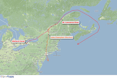
Let's say winter's chill was something you could no longer take as a Great Lakes sailor. Or perhaps you just want to extend your sailing season beyond the boundaries of summer. What options do you have?  You could just opt for a bareboat charter somewhere in the Caribbean and consider the itch scratched. But then you'd miss out on all the adventure of moving a boat between the Great Lakes and the Caribbean. And you wouldn't be sailing your boat. I'm here to convince you that the best option is to sail your own boat south. What follows is an overview of the route you could take to get you and your boat to warmer water and weather from the Great Lakes.

Route 1: St. Lawrence Seaway (including Lake Champlain shortcut)
You're adventurous if you choose this route. From most starting locations in the Great Lakes, you'll also be seeing the most scenery and passing the most water beneath your keel. Some of the most beautiful natural coastline anywhere in the world can be found in the northeast Canadian provinces and along the coast of Maine, which are all potentially part of this route. Additionally, you'll pass through the picturesque Thousand Islands area of Ontario as you exit Lake Ontario and head towards Montreal. Because of the extra mileage required when taking this route, it's generally advisable to get an early start (~July 1 or sooner). Another advantage is being able to leave your mast up for the entire route. The other routes will require you to un-step and step the mast at least once.

The St. Lawrence Seaway is actually a series of locks, canals and rivers that connect the Great Lakes to the Atlantic Ocean. Officially, the seaway extends from Montreal to Lake Erie and includes the Welland Canal. The route also includes 15 total locks. There's a minimum vessel size requirement of 20 feet and 1 ton to transit the seaway. More than 2,000 recreational pleasure craft pass through the seaway each season and as such, there area special docks and tie-up areas along the seaway for overnight stays and extended stops. Seaway staff are often available to help with tie-ups and locking through. Be sure to bring good fenders and/or fender boards to protect your boat from the cement lock walls.

Be aware that commercial traffic takes priority on the seaway and pleasure craft will often be asked to wait while commercial vessels pass through various locks. You'll also need to be aware of unbound (from the Atlantic) and down bound (toward the Atlantic) shipping lanes. Once you reach Montreal, the St. Lawrence River will take you past Quebec and out to the Gulf of St. Lawrence where you can explore Newfoundland, Labrador and New Brunswick if your interest and time allow.  The St Lawrence River and Gulf of St. Lawrence are not for the inexperienced, as the extreme tides and currents can make navigation challenging. In fact, the Bay of Fundy inside of Nova Scotia has the highest tidal range in the world with a mean spring range of 47.5 feet. That's right, the water level can rise or fall up to 47.5' in just 12 hours! If leaving the Great Lakes, the current in the St. Lawrence River will be your friend, but coming home on this route can be an upstream battle.

Lake Champlain shortcut: Take the Richelieu River from its confluence with the St. Lawrence River at Sorel-Tracy, Quebec (downstream from Montreal) to Lake Champlain and then follow the Hudson River from the southern end of Lake Champlain through Albany to New York City. This bypasses most of the St. Lawrence River and the entire Gulf of St. Lawrence in favor of a quick trip through New York state ending at the feet of Lady Liberty.

Congratulations, you made it to the Atlantic Ocean! Now point the bow south and start making some headway towards warmer water. You've still got options. The most popular is to catch the Intracoastal Waterway (ICW) and head south to Florida before making your jump across the Gulf Stream. Or you can pick one of many jump-off spots to begin a blue water passage from the east coast of the U.S. direct to the Virgin Islands. Or perhaps a mid-passage stop-over in Bermuda is more your flavor. In any case, you're now in saltwater and have the world sprawled before your bow.

Route 1: St. Lawrence Seaway (click the picture for a larger view)
Pros:
   - Scenery (Gulf of St. Lawrence, ect.)
   - Mast stays up
   - Potential for more sailing

Cons:
   - Longest route
   - Difficult navigation (currents, open water, extreme tides)
   - Few services beyond Quebec City

Summary: A great route if you've got time, experience and an adventurous spirit.

Additional information for this route

Route 2: Erie Canal (including Trent-Severn Waterway, Welland and Oswego Canals)
This is likely the most popular and/or common route from the Great Lakes to the open ocean. Know that you'll need to take the mast down to transit the Erie Canal at a rate of about $4-$8 per foot of mast. There are decent boatyards at both ends experienced in helping cruisers unstep and step their masts. Remember to be prepared with a means of carrying and supporting your mast on deck when it's down.

There are also at least a few variations to consider within this route. Your first decision point will have to be made somewhere in Lake Huron (if you're coming from the Upper Great Lakes). You can either make your way to the far southern end of Lake Huron and follow the St. Clair River into Lake St. Clair and on south through the Detroit River into Lake Erie, or take the Trent-Severn Waterway south out of Georgian Bay on Lake Huron through Ontario's "cottage country", including Lake Simcoe, and on through a series of locks to northern Lake Ontario. The latter route bypasses Detroit and all of Lake Erie and affords nice side trips through Lake Huron's North Channel and Parry Sound, both of which are legendary in the sweet water cruising world.

If you find yourself in Lake Erie, either by way of the Detroit River or because your homeport is there, you'll need to decide if you want to pick up the Erie Canal in Buffalo at the far eastern end of the lake, or if you prefer to transit the Welland Canal into Lake Ontario and make an eastward run to the Oswergo Canal in Oswego, New York. The Oswego Canal will take you about 24 miles south and meet up with the Erie Canal near Three Rivers and Liverpool.

At this point, all variations converge back on the Erie Canal near Liverpool, New York (outside of Syracuse) and are ready to continue the eastward voyage through the rest of the canal all the way to Albany. When you reach Albany, the trip will change and you'll leave the Erie Canal behind and head due south on the Hudson River all the way to New York Harbor. As a nice yin to the wilderness yang of the Gulf of St. Lawrence described in the first route above, the New York skyline and all of Manhattan will be on your port beam as you finally exit the Hudson River. Congratulations, you've made it to saltwater! See the continuing routes to the Caribbean described in the first route.

Route 2: Erie Canal (click picture for a larger view)

Pros:
   - Popular, well-worn path
   - Lots of good services for rigging/stepping
   - Potentially fastest route to the Caribbean

Cons:
   - Mast must come down
   - Lots of motoring
   - Potential canal/lock closures

Summary:
 This is likely the most common route from the Great Lakes to the ocean, so services and guides are plentiful.

Additional information for this route

Route 3: Mississippi River (including Ten-Tom Waterway)
This third option for exiting the Great Lakes and making your way to saltwater may not sound as enticing, but there are some perks, so read on!  You’ll essentially be completing the western portion of the Great Loop as you exit southern Lake Michigan at Chicago via the Chicago River and shortly thereafter the Des Plaines River.  This is a downstream run, so while your mast won’t be up, your iron genny will still get some help from Mother Nature.  As you meander past Peoria, you’ll see some of the heartland to both starboard and port.  The Illinois River will eventually dump you into the Mississippi River just north of St. Louis, Missouri.  The popular looper route will have you going up the Ohio River near Cairo, Illinois just a short distance to the Tennessee River and eventually back down the Ten-Tom (Tennessee-Tombigbee) Waterway all the way to freedom from a landlocked existance in Mobile, Alabama.  You can also stay the course on the Mississippi River south past Memphis, Tennessee and on through Greenville, Mississippi.  You’ll still eventually reach the ocean, but with this variation exits the continent near New Orleans, Louisiana.        

If your homeport is on Lake Michigan or your ultimate destination is somewhere in the Gulf of Mexico or (lucky you!) the Pacific Ocean via the Panama Canal, heading down the Mississippi may make the most sense logistically.  Touring through the Chicago metropolis on boat is considered a perk of this route by some.  The Ten-Tom Waterway is a nice aspect of this route, as it’s a treasured inland water resource for southern boaters.  Lastly, you’ll have easy access to Florida’s gulf coast and the Keys/Dry Tortugas, which can be a destination unto themselves.  This route also allows for a later start, so if you can’t break away in July or even August, coming south through the middle of the country might be a viable option for keeping your winter cruising plans alive.

Route 3: Mississippi River (click the picture for a larger view)

Pros:
   - Good option from Lake Michigan
   - Ten-Tom Waterway is enjoyable
   - Easy access to Gulf of Mexico and Florida Keys

Cons:
   - Mast must come down
   - Lots of motoring
   - Lots of commercial traffic and monotonous stretches of river

Summary: This route can save time/distance if you're in the western Great Lakes or if you've already cruised the east coast and ICW.

Additional information about this route


Editor's Note: If you've completed any of the above routes, I'd love to hear your opinion and any additional details and tips you may have.

Thursday, February 23, 2012

Book Review: Time of Wonder (by Robert McCloskey)

Looking out at Penobscot Bay from Camden, Maine (by K. Walters)
I've read a lot of great books.  Almost all of my favorites are non-fiction works that either tell the story of someone's journey, document an adventure, describe the science behind a natural phenomenon, or give a look into a historical event.  Time of Wonder by Robert McCloskey is a fiction book that does none of the above.  In fact, it's a children's book.  But it also happens to be my very favorite children's book.  I've read it with my daughters on many occasions and it still makes our senses and our minds come alive.  

McCloskey weaves a tale of a summer spent at the family cottage on an island in Maine's incredibly beautiful Penobscot Bay.  You follow the siblings in the story like their shadow as they listen to a rain approaching the shore, as they spend a foggy morning on the edge of nowhere, and as they sail near "porpoises puffing".  The idyllic summer begins to close as the community among the neighboring islands share in preparations for a late summer hurricane.  You'll find that this children's book becomes a page turner as the storm nears its' landfall.  McCloskey is a master at poking your senses with finely crafted, yet simple sentences.  

Have a quick read for yourself...
"Take a farewell look at the waves and sky.  Take a farewell sniff of the salty sea.  A little bit sad about the place you are leaving, a little bit glad about the place you are going.  It is a time of quiet wonder - for wondering, for instance: Where do hummingbirds go in a hurricane?"

Maybe my own fond childhood memories of summer vacations along the Maine coast (Boothbay Harbor, Penobscot Bay, Bar Harbor) make it ridiculously easy for me to like this book.  Could be the time we took our oldest daughter (then just 2 years old) camping along Penobscot Bay.  Or perhaps it's the cover image of two young sailing sisters that reminds me of my own daughters.  Or maybe it's the way McCloskey weaves summer, sailing, and the sea into a story that holds my kids' attention.  No matter the reason, I think you'll like it too.  After all, Time of Wonder is a Caldecott winner for "the most distinguished picture book for children" in 1958.  

If you're interested, you can purchase Time of Wonder from Amazon.com by clicking on the book cover in the sidebar to the right, or just wander over to your local library.
Can you smell the salt air? (On the rocks in Acadia National Park - by K. Walters)

Saturday, February 18, 2012

SailFar Films Presents..."Journey to the North Channel"

If a picture is worth a thousand words, a video (with pictures embedded!) must be worth at least a million.  Now that all the excitement from the trailer to our latest movie has built, we present to you the full feature film...Journey to the North Channel.  (You did watch the trailer, right!?)

Grab some popcorn, sit back and enjoy the show in full HD! (Click the full-screen icon in the lower right corner of the video player for a bigger picture.)


Wednesday, February 15, 2012

An Incredibly Normal Trip Around the World

Sailing vessel Guppy has made landfall (in case you haven't already heard)!  And her captain, Laura Dekker, is now the youngest person to have circumnavigated the Earth single-handed.  Laura completed her circumnavigation on January 21, 2012 in Simpson Bay on Sint Maarten.  I've written before about sailing records and my mixed emotions when it comes to young sailors (Laura set out when she was just 15 years old!) and these mind-blowing attempts.  The bottom line is that I couldn't possibly support such an attempt by one of my own daughters.  But if I'm completely honest, there's also a part of me that is majorly impressed with Laura's accomplishment.

Here's a bit from Laura's blog about the end of her amazing journey:

"The dark and starry night sky slowly vanishes its floating lights sprinkling to dust as small islands appear on the horizon. I can see Sint Maarten very far in the distance. St. Eustatius is behind me, Saba is abeam and St. Bath is on starboard. The Simpson Bay bridge opening is for 3 pm this afternoon so I have to keep at a maximum speed of 4 knots but even with the mainsail reefed, the Genoa furled and the mizzen Guppy is still going at 5,5 knots... 366 days ago I was sailing by on the opposite side of those islands heading southward as I watched Sint Maarten fall over the horizon. Now I recognize the shape of the islands and it sinks into my mind that Sint Maarten is just ahead, that I have circumnavigated the whole world in one year... solo. I decide to bring about Guppy as a strong squall is coming on us and anyway she is already going too fast. A heavy curtain of rain hides the islands from me and I am annoyed that even though Sint Maarten is right there close, I still have to wait. But two more hours are nothing to 41 days of sailing. So I am an hour away from St. Barth, and I have stopped our progression to wait for the signal from Sint Maarten to come in. I sailed around the world and I am still surprised that it just feels so incredibly normal..."


Amazing that she now belongs to a club with just one member but still feels "incredibly normal".  I'm also impressed that of the multiple youngsters who have attempted to set this record recently, Laura's attempt came with the least fanfare.  I believe Laura when she says this wasn't about publicity, money, or the record per se.  Rather, she wanted to see if she could rise to the challenge and learn a thing or two about life.  Mission accomplished.  As if sailing around the world wasn't enough, Laura and her father  have already sailed on from St. Maarten aboard Guppy and have now recently arrived in Bonaire.  Apparently sailing is incredibly normal for the Dekker family.

So what's your opinion of Laura's circumnavigation?

Saturday, February 11, 2012

Sweet Sunny Sleep

Sailing vessel Island Bound running before the wind
 under her sunny spinnaker
As you've probably gathered if you've been feeling the rhythm of this blog, I like to occasionally interject sailing-related quotes. Though the words in the quotes are not my own, most all have inspired me to write, to think, and to reflect. Words have the power to take our minds on a journey to another place and another time. This morning I made the mistake of watching the Saturday news. The opening four stories featured war (nuclear weapon "achievements" in Iran), murder (the Powell tragedy in Utah), religion feuding with government (contraception and the Catholic church), and child abuse (Sandusky molestation trial). "Kids, cover your eyes and ears, dad needs to find the off button!" How very thankful I am that there isn't a television cable long enough to reach my little sloop when she leaves the chaos of the shore.

And so today I bring you this quote...

"There's no opium so sweet as the unguarded sunny sleep on the deck of a boat when it's after lunch in summer and you don't know when you are going to arrive nor what port you will land at, when you've forgotten east and west and your name and your address and how much money you have in your pocket."


Those are the words of American novelist and artist, John Dos Passos. Many (most) of Passos' writing is political at some level, and while I'm not long for politics and it seems there will be almost no escape from election rhetoric over the coming year, I like the quote. It's soothing here in February to close my eyes and feel the July warmth of "sunny sleep" on Island Bound's deck. I've already written about the freedom described in the second part of the Passos' quote, but I think it's telling that someone as political as Passos can find escape on the deck of a boat too.

So whether you're reading this in the office, at home, at school, or on your boat, take a moment to feel the the warmth and refreshment of a "sunny sleep". 

Wednesday, February 8, 2012

Cruising with Kids: Don't Leave the Dock Without Them!

Sailing wouldn't mean nearly as much to me if I couldn't share the joy that it brings me with my children.  In fact, when I sail with my kids, the two biggest joy-producers in my life collide to create my fondest memories.  I guess I'm lucky that my kids love sailing nearly as much as I do.  I've been told that a teenage day may come when they'd rather be somewhere other than harnessing the wind with dear old dad.  But until that day comes, you can bet I won't be leaving the dock without them.  Anyone else with kids knows that cruising and sailing takes a few special considerations to accomodate their needs.  What follows are my tips for cruising with kids on board.

Use jacklines, harnesses and tethers.  Safety is a major consideration whenever you sail with kids, but what exactly do you need to do differently?  If we're cruising, we typically have our jacklines installed on deck, even if the kids aren't with us.  But when they are with us, the rule on our boat is that the kids must wear harnesses and be tethered to the jacklines if they are on deck while we're underway.  Obviously, conditions must be calm for the kids to be allowed on deck in the first place.  Depending on your cockpit design and the conditions, you might also consider tethering your kids when they are in the cockpit.  A simple pad eye provides a good tether attachment.  There are multiple kid-friendly harness and tether systems available.  We use the Children's Safety Tether/Harness from Cal June.  This rig is lightweight and kid-sized.  It's not necessarily designed with offshore work in mind, but considering it's for kids it does the trick.

Notice the PFD's, jacklines, and tethers. Harnesses are hidden
beneath the PFD's. Lifeline netting is also visible.
Life Jackets/PFD's are a must.  This one almost goes without saying, given that the U.S. Coast Guard and most states actually require children of specific ages to wear life jackets at all times.  Even without local regulations and requirements, our kids wear life jackets whenever they are anywhere on the boat, except in the cabin.  This includes while docked or anchored.  Additionally, there are certain conditions where we require our kids to wear life jackets even while in the cabin.  During rough passages and when excessive heeling and/or tacking is expected, wearing a life jacket in the cabin can help protect ribs and shoulders from injury if they fall down.  We recommend letting your children help pick out their own personal life jacket so that it's comfortable and fashionable in their eyes, which helps ensure they'll have a better attitude about wearing them.  It's a net-positive if your kids want to wear their life jackets even if you have to endure the sight of Winnie the Pooh or Barbie on your otherwise classic and classy ketch.

Get kids involved.  Let them turn a halyard winch, or steer, or operate the GPS, or help with the dock lines.  The more they're involved with actually sailing the boat, the more they'll love and understand sailing.  Both of our daughters now instinctively know that it's their job to help secure dock lines when we return from a sail.  They also both can name most of the features on the boat (standing rigging, mainsail, mainsheet, tiller, shroud, spreader, etc.) and their purpose.

Learning how to stand watch at just 5 years old!
Lifeline netting.  Install some today.  While jacklines and tethers will keep your kids on board, netting adds another level of security and also helps keep other objects that invariably get dropped on deck (boat hooks, fenders, etc.) from falling off.  Another bonus: lifeline netting keeps dogs from falling overboard too!  Our netting isn't the fancy cargo-net style you can buy at West Marine, but rather just some simple thin cordage laced between the lifelines and toerail (see the first picture in this post).   

Give them their own "corner" of the boat.  Just like at home, kids need a space on the boat that they can call their own and set up to their liking.  Our kids use this policy liberally and often commandeer the entire cabin while we're out sailing.  It's not uncommon to see stuffed animals, Polly Pockets and coloring books strewn from the chain locker in the vee berth clear back to the aft quarter berth.  Maybe we need to tighten up the boundaries on their personal boat space, but you get the idea.

You can tell these two don't like cruising at all.
Instilling a love and respect in my children for sailing is important to me.  Being safe, having fun, and having responsibilities are all part of the equation.  If I play my parental cards right and at least one of the little buggers ends up with my sailing addiction, perhaps one day when their dad (me) is too old to sail and is considering a trawler, they'll have a nice Oyster 54 I can hitchhike aboard.

Sunday, February 5, 2012

What's Your Destination?

Seems like a lot of my recent blog posts have focused on navigation and reviews of navigational equipment, so I thought it might be a good time to interject another quote.  This one is from Frank Bama, a fictional character in Jimmy Buffett's novel titled Where is Joe Merchant?

"The best navigators are not quite sure where they're going until they get there."

Well said, don't you think?  Sailors understand that life is all about the journey, not the destination.  Apparently, Frank Bama gets it too.  What would happen if we all focused a bit more on where we are instead of where we are going?

And in honor of the mid-winter warmth we're getting here in the Great Lakes, I'm posting the following warming picture:

February sunrise in St. Kitts (photo by K. Walters)

Wednesday, February 1, 2012

Looking for Affordable AIS? Here's a Few Low Cost Options

Automatic identification systems (AIS) have been catching on with recreational boaters and cruisers over the last several years.  While commercial ships have used the system for many years, the technology has been becoming more affordable for smaller private vessels.  If you haven't heard of AIS, it's essentially an automatic tracking system used to identify and locate vessels by digitally exchanging data with other nearby vessels and base stations.  Data often includes vessel position, heading, speed, destination, and a variety of other information.  AIS systems can't replace a good on-deck watch or radar for collision avoidance, but they do offer a reasonable supplement.

AIS Overview from the International Maritime Organization

As a recreational user, you have basically two options: 1) Purchase an AIS receiver that allows you to accept and view AIS data from other vessels, but does not transmit your own data; or 2) Purchase AIS equipment that allows you to receive and transmit data.  Obviously, transmitting your own data (position, heading, speed) is an important component of collision avoidance because not only can you avoid traffic with your own vessel, but if you transmit, traffic can conceivably avoid you.  Costs to equip your boat with AIS typically begin in the $400 for receiving equipment, and go up from there.  What follows are reviews of a couple of low cost alternatives (But be aware of their fairly major limitations!).

Ship Finder HD Free App Review
As most regular readers of my blog already know, I'm smitten with Apple's iOS product line for sailing and cruising.  Being afflicted with this hi-tech ailment means I'm practically mandated to write a few reviews of apps applicable to cruisers.  Ship Finder HD Free falls into this category and does indeed show the location of vessels equipped with AIS transmitters on a Google Maps display.  If you want anything more than just the vessel name and position plotted on a Google map, you'll need to purchase the full version for $6.99 (as of 2/1/12) in the App Store.  It's also very important to remember you're only seeing vessels equipped with AIS transmitters and you yourself are NOT transmitting your location (and other data) to those vessels.  Those vessels can only see you if they are using their eyeballs on the horizon or are picking you up on their radar.  Another thing to keep in mind is that you'll need either a WiFi or cellular (3G) signal to use this app.  In other words, this isn't going to work for bluewater passages.  In fact, while I enjoy using this app, it's really more of a toy than a bonafide navigation/collision avoidance tool.  But hey, it's free, so why not give it a try if you've got an iOS device?  If you don't have an iOS device you can still view Ship Finder data at http://shipfinder.co/.
Ship Finder Free HD screenshot
MarineTraffic.com Review
If you don't have an iOS device or you're looking for a web-based solution for receiving AIS data, MarineTraffic.com may be for you.  Vessel position is shown in Google Maps just like in Ship Finder, but you also have access to additional free information like speed, course, vessel length, beam, draft, and destination.  Essentially, you're getting all of the paid Ship Finder features for free.  However, you'll have to deal with HTML browser formatting and advertising, as well as still needing WiFi or cellular data reception.
MarineTraffic.com screenshot
My choice among the above two free AIS options would be MarineTraffic.com simply because it offers more data in virtually the same format.  But ultimately, if you're looking for real AIS features and the additional potential collision avoidance that comes along with more traditional onboard AIS systems, I recommend investing in an actual AIS transmitter/receiver that functions with your existing chart plotter and/or VHF radio.

Once again, I'm forced to admit that while Apple and iOS devices provide a very friendly user interface experience, they still can not replace more traditional dedicated marine navigation devices.  I have no doubt that as iOS matures and Apple expands its' already expansive market share, iOS devices will eventually begin to more evenly compete with marine electronics stalwarts like Garmin, Ray Marine, and Sim Rad.  As always, please feel free to share your comments, experiences, and opinions using the "comments" link below.