Posts

Showing posts from July, 2010

Video updates from the North Channel

Now that we've got about a week of down time while we're taking care of some business and waiting to get back to Island Bound in Charlevoix, I thought I'd share some videos we've shot during the cruise so far.  Enjoy! Meldrum Bay to Gore Bay Covered Portage Cove South Benjamin Island Whalesback Channel Topaz Lake

Lake Charlevoix to Grand Traverse Bay

Image
Charlevoix (Horton Bay) to Suttons Bay: 38NM - July 20 Next on our cruise itinerary was a short 4 day side trip to Grand Traverse Bay. Grand Traverse Bay is another place I’ve visited often from land. I have always longingly looked out at the open blue water imagining myself sailing. I can now attest that the big bay is an excellent sailing location and a cruiser’s paradise. We left Lake Charlevoix in the morning and motored in the very light air direct to Suttons Bay. While there was plenty of room at the marina we decided to stay on the hook in the south end of Sutton’s Bay and use the dinghy for shore side adventures. After anchoring we all quickly put on bathing suits and jumped into the clear, 25 foot deep water to deal with the building humidity. I snorkeled around the anchorage and saw sunken old docks, lost mooring equipment and lots of other unidentifiable pieces of lumber. On shore we met up with my mom and dad (Grammy and Poppa), who just happened to be visiting with some ...

Harbor Springs to Charlevoix

Image
Harbor Springs to Charlevoix (Horton Bay): 25NM - July 16 through 19 Waiting for better weather proved to be a good move as the lake was much calmer the next day and we were able to motorsail with Otto at the helm for most of the 25 nautical miles from Harbor Springs to Charlevoix. N ana, Bumpa and the girls met us in Round Lake in Charlevoix on their boat as we came into the harbor. We all went ashore for lunch and Venetian Festival activities before sailing down Lake Charlevoix to Horton Bay. Ever since I met Erin back in 1990 and started coming with her family to the cottage and Lake Charlevoix I’ve dreamed of sailing down the long, beautiful lake through the blue/green waters. Yet again, our summer cruise has allowed me to realize another of my sailing dreams. We borrowed a mooring ball in Horton Bay and kept the boat moored while Erin, Isabel, Hannah and I soaked up a few days of life ashore. We were able to stretch our legs, catch up on laundry and sleep in a bed with an hon...

Mackinac City to Harbor Springs

Image
Mackinac City to Harbor Springs: 47NM - July 14 & 15 Erin and I got a mid-morning start on the route from Mackinac City to Harbor Springs after enjoying a quiet breakfast together at a restaurant in Mac City. After leaving the marina we quickly passed under the mighty Mackinac Bridge and were in awe of the view from beneath. The weather began to deteriorate as we moved westward towards the abandoned lighthouse east of Gray’s Reef and offshore from the mainland. Waves were building to from 2 to 5 feet and the sky darkened with rain clouds. It wasn’t long before we were motoring into the wind and waves in an intense downpour. Surprisingly, this is one of the few times we’ve need our foul weather gear on this trip. The rain stopped after about an hour and the skies cleared but the seas remained lumpy as made our way past another mid-lake lighthouse (Ile Aux Galets Light) and into the relative protection of Little Traverse Bay. Harbor Springs was busy with summer cruisers so we were...

Drummond Island to Mackinac City

Image
Drummond Island to Mackinac City: 48NM - July 13 We’ve covered a lot of ground since the last blog post. After checking back in to the United States through US Customs, we departed in the morning for a westward run through the Straits of Mackinac to Mackinac City where we met up with Erin’s mom for lunch. Sailing past Mackinac Island for the second time on this voyage made us realize just how far we’ve sailed this year. Isabel and Hannah rode with Nana back to the cottage in on Lake Charlevoix while Erin and I stayed in Mackinac City and reprovisioned to sail the boat west and then south so we could eventually meet back up with the girls on Lake Charlevoix.

Turnbull Island to Drummond Island

Image
Turnbull Island to Drummond Island July 13, 2010 67NM We awoke at 5am to light air and fog as we departed Turnbull Island just before sunrise. I always feel blessed to see the sun come up over the water and light the way ahead of the bow. Seeing it many times on the trip is something I’m thankful for. Our intended route back to the United States would take us from Turnbull then south of Missasagi Island and across the North Channel proper to False Detour Channel between Cockburn Island in Canada and Drummond Island in the United States. In so doing, we were able to circumnavigate Drummond Island since we took Detour Passage coming into the North Channel several weeks ago. Next we were headed to Whitney Bay and Fort Drummond on the south western side of Drummond Island to clear customs. The trip was to be something like 55 nautical miles and take around 10 hours. Our somewhat dated guide books said there was a U.S Customs Office at Fort Drummond Marine in Whitney Bay…but when...

Long Point Cove to Turnbull Island

Image
Long Point Cove to Turnbull Island July 12, 2010 5NM It was just a quick hop over to Turnbull Island from crowded Long Point Cove. Turnbull is our last island to visit on this trip to the North Channel, so we all have bitter-sweet feelings. The anchorage at Turnbull is big and protected by the many small island to the east. We picked a spot tucked into small corner, set the anchor and began to explore with our dinghy. We had been told by several other cruisers that there was at least one nesting pair of bald eagles in the small islands surrounding Turnbull, but we were unable to find the nest after about 2 hours of searching. Back at Island Bound we all went for a late afternoon swim and settled in for a quiet evening of family games. Erin and I woke at 5:00am the next morning to begin the long sail back to Drummond Island and the United States.

Beardrop Harbor to Long Point Cove

Image
Beardrop Harbor to Long Point Cove July 11, 2010 8NM It was just a short distance from the beauty of Beardrop Harbor to the much anticipated Long Point Cove. We sailed lazily under full sail in light air and trolled with a NorthPort Nailer and our Dipsy Diver for salmon to no avail. Just the same, the cruise over to Long Point Cove was a relaxing way to spend the midday. In the distance to the west we could see Turnbull Island and the open waters of the western part of the North Channel. We were quietly reminded that our time in the North Channel was coming to a close. However, I’m sure to spend more time here in my mind this winter pouring through the memories we’ve made. Long Point Cove proved to be a popular anchorage as we came in past Navy Island and saw 15 other boats already at anchor in the tiny cove. We took our time idling around the cove and weaving between the boats while carefully picking a perfect spot where we could swing at anchor without worry of bumping the oth...

Spanish to Beardrop Harbor

Image
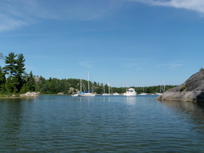
Spanish to Beardrop Harbor July 10, 2010 15NM The nice new marina aside, there wasn’t much to keep us in Spanish for very long. But the truth is that even if Spanish had all the amenities of our home marina (pool, showers, playground, etc.), you’d be hard pressed to keep us there longer than necessary to reprovision. You see, we’ve grown quite fond of life on the hook in the islands of the North Channel. There’s something freeing about being unplugged from electricity, cellphones, internet and the sounds of civilization. At anchor you learn what you really need and you learn how to get it. You learn what you don’t need and you live without it. Life at anchor is just that simple. So we left Spanish behind and headed out into the Whalesback Channel eager to “live free and sail far” during the relatively small amount of time that remained for us in the North Channel. The bow was pointed west towards Beardrop Harbor as we moseyed along under full sail in 8 knots of a southwestern...

South Benjamin Island to Spanish

Image
South Benjamin Island to Spanish July 9, 2010 12NM I won't lie, it was hard to leave the beauty of South Benhamin Island.  Not only was it hard to mentally leave, but it was also physically hard to get the boat out of such a tight anchorage with the wind building from the west.  We managed to do so and began making our way through the navigational hazards on the way to the small village of Spanish, Ontario.  First we had to negotiate the rocks west of Eagle Island, then it was through the small pass into the McBean Channel.  From the McBean, we had to announce a security (say "Say-cure-i-tay") on VHF channel 16 as we entered passed through Little Detroit, the tiny rock cut connecting the McBean Channel to the Whalesback Channel.  Once in the Whalesback, we had to weave our way around Whiteaves Island on approach to the shallow channel leading to Spanish.  The Spanish channel is suppos...

South Benjamin Island

Image
South Benjamin Island July 8, 2010 The day before had been so picture perfect that we decided to stay two nights in our cozy anchorage on South Benjamin Island. The Benjamins are the jewel of the North Channel because of the many perfect anchorages, the crystal clear blue water, the superb blueberry picking and most of all the breathtaking landscape. So instead of blogging about how beautiful it is here, I thought I’d let some pictures speak a thousand words…

Croker Island to South Benjamin Island

Image
Croker Island to South Benjamin Island July 7, 2010 4NM The trip over from Croker to South Benjamin Island was short but full of navigational challenges. We had to retrace our previous course around Porcupine Island and then between the Sow and Pigs and Secretary Island. Then we turned west and watched carefully for shoals along the southern rim of the Sow and Pigs as we neared South Benjamin Island. We were somewhat familiar with South Benjamin as we had anchored one night here previously in stormy weather. This time we were seeking out one of the small little “hidey-holes” in the narrow rock passage on the southern end of the island that we had previously explored with our dinghy. To our surprise we found our preferred spot empty and we carefully wove our way in at idle speed with a bow watch. Because of exploration with the dinghy we knew we had about 8 feet of water to play with in the tiny rock cove we intended to stay in. This particular spot is mostly known by locals and ...

Kagawong to Croker Island

Image
Kagawong to Croker Island July 6, 2010 14NM We topped off the fuel tank and pumped out the holding tank in the morning in Kagawong just prior to departing for multiple days at anchor in the Benjamin Island group. The wind was 8 to 10 knots out of the southwest and we had a delightful sail all the way to Croker Island under the headsail alone. The approach to Croker Island meant we had to correctly identify Secretary Island and the Sow and Pigs, keeping Secretary to starboard. After passing Secretary Island we chose to take the safer deep water entrance to Croker’s inner harbor by passing north of Porcupine Island. Croker’s main harbor had three other boats at anchor but we snuck into the smaller harbor behind the tiny unnamed island within the harbor for a quiet night by ourselves. After securing the anchor we all swam for at least an hour and enjoyed the rocky landscape of our surroundings. I snorkeled around the small harbor and tested my diving ability to see if my recent a...

Matheson Island to Kagawong

Image
Matheson Island to Kagawong July 5, 2010 16NM After several nights out at anchor on small islands it was time to go re-provision and explore another of the North Channel’s small villages. This time we were on our way to the southern end of Mudge Bay and tiny Kagawong, self-proclaimed as the prettiest little town on Manitoulin Island. Kagawong means “place where the mist rises from the falls” in Ojibwe. So if the mist rises from falls, there must be a waterfall somewhere in Kagawong, right? It didn’t take long after we were docked before we were hiking the well groomed one mile trail out to Bridal Veil Falls. The falls drop about 100 feet off a shear rock cliff into a pool below. We waded in the pool and also carefully walked behind the falls on the slippery clay for a unique look out at the world. We had lunch at an Irish tea shop called Tweebles up a steep hill on Main street. We also checked out a cool stone maze and tree maze where the girls played hide-and-seek in the humi...

Louisa Island to Matheson Island

Image
Louisa Island to Matheson Island July 4, 2010 6NM As you’ll notice if you’ve been following the nautical mileage I post in all the headings, our daily mileage has shrunk and we’ve been spending less time sailing and more time relaxing at anchor. This is by design. Now that we’re midway through our cruise (1 month behind us, just over a month ahead of us) and we’re in the heart of the North Channel we’re taking it slow and stopping at all of the anchorages that call to us on the charts. Today’s destination is little Matheson Island along the North Channel’s northern shoreline. This pretty little rock island has a nice natural harbor that’s protected from the southwest winds forecast for today. As it turns out, we’re the only boat at this off-the-beaten-path island and so we’ll celebrate America’s Independence Day as a family enjoying our freedom to travel, freedom to explore and freedom to grow! Bare in mind, this is a cruiser’s celebration somewhere between here and there so w...

Sturgeon Cove to Louisa Island

Image
Sturgeon Cove to Louisa Island July 3, 2010 4NM After listening to the Cruiser’s Net on VHF 71 and calling in our location, we made plans for our departure from Sturgeon Cove. Getting out of Sturgeon Cove’s rock-maze entrance was just as fun as getting in. So long as you’ve studied the charts, post a bow watch and know how to line up the range markers on shore, the entrance isn’t as bad as the guide books make it seem. Next it was a quick hop over to the small cove on Louisa Island’s eastern shore. Yes, yet another beautiful rocky anchorage. But this time we were joined by about 6 other cruising boats. We use the “North Channel Tie Up” with a bow anchor and a stern line tied to a tree on shore to keep us from swinging into the other boats in the cozy little cove. At the center of the cove was another sandy beach which we all swam to from Island Bound. The water felt great in the 80 degree heat of midday. Later that day a 32 foot center cockpit ketch (s/v Western Whim) anchor...

Little Current to Sturgeon Cove

Image
Little Current to Sturgeon Cove July 2, 2010 7NM Our plan for today was to make the short hop up the Wabauno Channel to a little used anchorage behind Mosquito Island. However, winds were from the southwest and this would leave the anchorage exposed to waves building out in the channel. Another option was Sturgeon Cove on the northern shore of Great Cloche Island, but the entrance to the cove is riddled with rocks and shoals and most guide books recommend caution when going there. We have been meeting quite a few fellow cruisers along the way and crews from two boats suggested we give Sturgeon Cove a try after hearing their guidance and experiences with the entrance. The crew of s/v Kismet even invited us aboard there Catalina 40 to review the Great Lakes Cruising Club’s Pilot Guide and hand made chart for the cove. While aboard s/v Kismet, I reviewed the entrance procedures while Isabel and Hannah played with Kismet’s canine crew of two Dalmatians. The crew of s/v C’est La Vie wa...

Baie Fine to Little Current

Image
Baie Fine to Little Current July 1, 2010 22NM The first day of July brought summer weather with it after almost a week of cool, overcast days and intermittent showers. July 1st also had other significance in the North Channel as it is Canada Day, the equivalent of America’s Fourth of July. We were leaving Baie Fine, the eastern stops in the North Channel and several days at anchor behind as we had an amazing sail to Little Current. Erin and I even had time to enjoy the ride on the rail as the girls played in the cabin and Otto manned the helm without complaint. We topped off our gasoline tank and pumped out the holding tank at Wally’s just prior to tying up at the town docks in Little Current. We were greeted with the sounds of live music and Canada Day celebration as we tidied up Island Bound. The main street in Little Current was closed to traffic and the townspeople set up art, craft and food booths along the sides. The live music continued until just after 8pm that evening. ...

Snug Harbor to Baie Fine

Image
Snug Harbor to Baie Fine June 30th, 2010 19NM The wind was still howling. The waves were still frothing with whitecaps. The crew of Island Bound was still full of a sailor’s gusto and wouldn’t be denied another of the North Channel’s treasures. So we pulled anchor in Snug Harbor and motored out the rest of Lansdowne Channel and then motorsailed with a sliver of the genoa unfurled with 25 knot winds on our port quarter, pushing us towards the much anticipated Baie Fine and the Pool. We couldn’t spot the all important green-red-green buoy marking the safe shortcut into Baie Fine with the cresting waves and spray from the wind so we prudently took the long approach around Duncan City Reef, keeping Caroline Rocks safely to starboard. Baie Fine (pronounced “Bay Fin”) is a very unique experience. The only other place in the world where you can visit such a fjord is in Scandinavia. Here in Baie Fine you can take your able craft right up the middle of the fjord with sheer granite walls ...

Covered Portage Cove to Snug Harbor

Image
Covered Portage Cove to Snug Harbor June 29, 2010 6NM As beautiful as Covered Portage Cove is, we were still eager to keep moving forward because the North Channel offers so many unforgettable spots. We’re starting to think that even an entire summer is not enough time to explore all of the anchorages, gunk holes, beaches and ports. Winds had been gusting to near gale force overnight and were expected to stay near 30 knots through the day. While Covered Portage Cove offers very good wind protection with its’ high bluffs, we knew that the short 6 nautical mile trip down Lansdowne Channel to Snug Harbor should also be fairly protected. After feasting on pancakes bursting with the wild blueberries we had found the day before, Island Bound was underway again. We arrived at the Snug Harbor anchorage after just a little over an hour of motoring into the wind and chop. With Erin on bow watch and myself at the helm we motored slowly across the shallow bar at the entrance to Snug Harbor....

Killarney to Covered Portage Cove

Image
Killarney to Covered Portage Cove 4.5NM We woke to a misting morning rain but still proceeded with our plans to go stay in one of the North Channel’s most popular and most stunning anchorages. Covered Portage Cove was just a short motor away, back through the rocky shoals of the Double Island Ledges. When you read about or talk with veteran cruisers about the North Channel, Covered Portage Cove always comes up. The entrance to the cove passes high rocky bluffs on the south side and a few scenic little coves on the north. The high bluffs create a really neat profile of an Indian chief’s face as round your way into Covered Portage Cove. Next the cove opens up with spectacular rock formations on both sides and teal-blue water and wind blown pines and cedars along the shore. After we were sure the hook was set we took the dinghy to shore in the far back end of the cove and began a steep hike up and around the back side of the rocky bluffs. The forest away from the cove was thick with...

Browning Cove (Heywood Island) to Killarney

Image
Browning Cove (Heywood Island) - Killarney 14NM Browning Cove was just what we dreamed a proper North Channel anchorage would be like. After spending such a wonderful day there it was hard to leave the next morning, but there’s always more to explore in the North Channel. We left Heywood Island behind in the light air of the morning and proceeded up picturesque Landsdowne Channel past Hole-In-The-Wall. Lansdowne Channel is well protected by the La Cloche Mountains to the north and Partridge, Center and Badgeley Island to the south. As we passed Maxwell Point on Badgeley Island it was time to weave our way through the tricky shoals of Badgeley Rocks and Double Island Ledges. The area is well known for Cash Flow Rock, the rock that many boats run hard aground upon and thereby help cash flow to the fiberglass repair shops in Killarney. With Erin posting a bow watch, I moved slowly ahead through the rocks to the channel leading into Killarney. The town of Killarney reminds me of the m...