Posts

Showing posts from June, 2010

Little Current to Browning Cove (Heywood Island)

Image
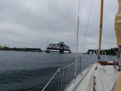
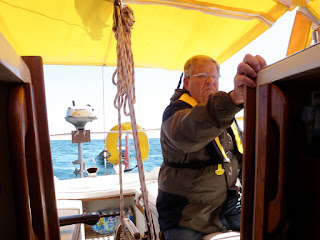
Little Current - Browning Cove (Heywood Island) 10NM We departed Little Current with clean laundry, freshly showered bodies and a full galley. The weather today was delightful…blue skies, temperatures in the mid 70’s and light winds from the southeast. Our eastward route took us through the swing bridge and very nearby the beautiful lighthouse on the tip of Strawberry Island. As Heywood Island grew larger on the horizon, we read up on its’ geography in our guide books. The low wooded island is know as a haven for many species of birds, including nesting bald eagles and loons. As a side note, it’s taken us a while to get use to calling the Canadian one dollar coin a looney like the locals do because of the loon pictured on the back. Heywood Island has one large and well protected bay on its’ northwestern edge with a small (~100 feet wide) channel stretching east behind tiny Browning Island into Browning Cove. This is where we chose to stay because of the privacy and the amazingly...

South Benjamin Island to Little Current

Image
South Benjamin Island - Little Current 16NM The day broke with an overcast sky but the winds from last night had subsided. We pulled the anchor around 8am and began motoring east towards Little Current, the largest town in the North Channel. The wind was light enough that the bugs were out for most of the 3 hour trip. We carefully rounded our way past the Sow and Pigs (rocks just south of the Benjamins), Croker Island and then south of Amedroz Island. As we entered the channel leading to Little Current, we hailed Spider Bay Marina on VHF channel 68 and reserved our slip. Spider Bay was about a ¼ mile walk from town but the marina has free wi-fi and coin laundry facilities on site, so we decided to make it home for one night. After safely docking next to several chartered sailboats, we began cleaning Island Bound . Next it was off to town for a stroll through the gift shops and a stop at The Pantry Café for lunch. I was treated to the special of the day, a Texas brisket sandw...

Gore Bay to South Benjamin Island

Image
Gore Bay to South Benjamin Island 14NM We left Gore Bay at noon under bright sun and scattered high clouds. The winds were heavy with a steady 20 knots blowing off our port quarter. There were gusts to 25 knots and waves building to 5 feet by day’s end. These weren’t ideal conditions, but we had a short sail planned and would have the wind and waves mostly behind us. Our original plan called for anchoring at Clapperton Island but with the heavy seas we didn’t think it would be safe to try and negotiate the many reefs guarding the western entry to Clapperton Harbor. Our goal is to make as much east as we can early in the trip, with Killarney and the end of Georgian Bay being our turnaround point, so Clapperton was to be a quick overnight stop on the way to Little Current and points east. The alternative we chose was South Benjamin Island, just a bit northwest of Clapperton. The sail over to South Benjamin Island was another rough ride. We had a double reef in the main and only ...

Meldrum Bay to Gore Bay

Image
Meldrum Bay to Gore Bay 32NM After having had the rare cruising combo of a meal at a restaurant and hot showers the night before, we were all feeling fresh and ready to continue eastward. We left tiny Meldrum Bay at about 6am and quickly hoisted the sails for what was to be an excellent close reach all the way to Gore Bay. Winds were generally 10-15 knots, but gusted to 20 when we weren’t in the lee of the many points on Manitoulin Island’s north shore. The boat hurried along at between 6 and 7 knots and 20 degrees of heel for most of the ride. By this point , Island Bound’s crew now has their sea legs and we’re all quite comfortable with the rhythm of morning passages, afternoon explorations (either of an island or harbor) and evening fun (games, singing, fishing, etc.). We’re still surprised that there aren’t more cruisers out on the water. We only see about one or two boats a day, which is more than we saw while in Lake Michigan. The marinas remain less than full and the anc...

Video Log - Sailing under the Mackinac Bridge

Just a couple of quick clips of our sail under the Mac Bridge...

Approaching Mackinac Island - Video Log

Just a quick snipit from our approach to Mackinac Island Harbor...

DeTour Reef Light Video Log

Here's a brief video of s/v Island Bound rounding the light marking DeTour Reef just south of Detour Passage.

Harbor Island Video Log

Here's a quick video showing our shore excursion on Harbor Island.  You can read more about our Harbor Island stopover in one of our previous posts.

Pilot Cove to Meldrum Bay

Image
Pilot Cove - Meldrum Bay 20NM The rain started falling at midnight in Pilot Cove and didn't let up until 8am.  Winds had increased to 10-15 knots from the east with gusts to 20 knots.  We pulled the anchor, which held very securely through the night, and started making our way east into 3-5 foot seas with the wind on our nose.  The ride was rough and wet, with spray and drizzle finding their way into the cockpit beneath the dodger and bimini.  We wore our foulies for the entire 4 hour trip over to Meldrum Bay on Manitoulin Island.  The girls brought their sleeping bags down to the floor of the salon and fell asleep for most of the passage.  As we cruised north of Cockburn Island and approached Missisagi Strait through the dense fog, we spotted a freighter between us and the shoreline.  It was difficult to make out the ship's heading through the fog, but was easy to tell we were getting too close for comfort.  I got on the VHF and hailed the "...

Harbor Island to Pilot Cove (Drummond Island)

Image
Harbor Island - Pilot Cove (Drummond Island) 20NM We all slept in and made a leisurely departure for tiny Pilot Cove on the eastern side of Drummond Island. The trip over was just under 4 hours. Hannah and I boarded Island hopper (our dinghy) to sound out the channel depth into Pilot Cove with our handheld depth finder prior to entering with the mothership. Unfortunately, the handheld depth sounder (Hawkeye XP100) wasn’t working, so we improvised and used a rope and rock to determine that depth in the narrow little channel leading into the peaceful and picture-perfect cove was only around 5 feet. This was too shallow to risk an entry with Island Bound. On paper, our sloop draws 4’6” of water, but we conservatively figure she probably has a draft of 5’ given the plethora of cruising gear we have aboard. No worries as the sand bottom and spit of land just outside of Pilot Cove provided a safe anchorage for the night as long as the wind stayed out of the south and/or east. Luckily, i...

Les Chenneaux Islands to Harbor Island

Image
Les Chenneaux Islands - Harbor Island 30NM As we left the “Snows” in our wake we pointed the bow east and inched closer to the North Channel. The wind was light so we mostly motored, but around mid-day the wind increased to around 8 knots and we decided to try out our symmetrical tri-radial spinnaker for the first time. After stuffing the sack and rigging all the required extra gear, we hoisted the big yellow and orange sail. It took us about 10 minutes to get it trimmed out but when it was, wow…what a beautiful sail and a fun ride! We were doing 5.5 knots in the light air. Eventually, the wind began to shift off our port quarter so we had to douse the spinnaker, but we can’t wait to get it out again sometime soon! We rounded the Detour Reef Light (complete with a man taking photographs of boats passing by) with a freighter steaming in off our starboard quarter. The freighter quickly overtook us as we all enjoyed the close up view of the big ship in the narrow Detour Passa...

Mackinac Island to Les Chenneaux Islands

Image
Mackinac Island - Les Chenneaux Islands 19NM Finally we had the perfect day for sailing. The winds were 10-20 knots out of the west which meant we’d be running downwind to the Les Chenneauxs. We started with 2 foot seas on our port quarter and the genoa poled out to port with the main held with a preventer to starboard. As the winds built we ended up on a broad reach with a single reef in the main. As we approached the channel in from Lake Huron to the Les Chenneaux Islands, the wind increased close to 20 knots and the waves built to 3-4 feet. The ride was fast and boisterous. As we eased the bow into the channel and the lee of Government Island, the boat stood upright and we cruised in to our cozy anchorage in Government Bay. There were two powerboats and two sailboats already swaying at anchor. We snuggled in between the two other sailboats and enjoyed another peaceful evening on the hook. We took our dingy in to shore and explored what seemed to be part of the national forest a...

Mackinac Island

Image
Mackinac Island After securing the boat, we promptly headed to the busy main street on Mackinac Island to take in the colonial charm of the architecture, lack of cars, and plethora of horse drawn carriages. Both Hannah and Izzy were amazed that bikes and horses did all the work of cars and trucks on this unique island. After grabbing a Mexican combo plate at a mainstreet pub, we climbed the steep trail up to Fort Mackinac. The Fort dominates the landscape from the southern view of the island. Seeing the picketed barrier fences, the old cannons and reading about the history of British and American soldiers at the Fort we were all taken back a to another the 19th century. Next it was on to the governor’s residence on Mackinac Island. Every incumbent governor of Michigan is gifted the use of a colonial styled white mansion perched high on the sandstone bluffs of the island just down the road from Fort Mackinac. A fiercesome boy scout stood guard the day we walked by. We continued o...

Beaver Island to Mackinac Island

Image
Beaver Island - Mackinac Island: 6/17/10 - 6/18/10 40NM I awoke with the sun on Thursday morning and pulled the anchor while all three “girls” slept soundly. I was eager to make the passage from Beaver Island to Mackinac as it’s one I’ve often envisioned while planning this trip. As I motored out of St. James harbor I was surrounded by the other islands in the Beaver archipelago. Both High and Garden Island beckoned as I continued east. Perhaps we’ll explore them on the way back home. Beaver Island to the mainland of Michigan’s lower peninsula covers a shallow area of shoals and reefs known broadly as Gray’s Reef. It’s eerie to sail several miles from land and still see the bottom and watch boulders and sand patches glide by beneath the hull. Most of the way from Beaver Island to the abandoned lighthouse marking the beginning of the Mackinac Straits is just 20 feet or less of water depth. We passed by a total of three mid-lake lighthouse on passage through Gray’s Reef, t...

Charlevoix to Beaver Island

Image
Charlevoix - Beaver Island: 6/16/10 26NM We left Charlevoix in the rain in time to make the second drawbridge opening of the morning at 6:30am. We were headed to Beaver Island. There was a thick fog on Lake Michigan as we left the protection of the pier head. We have a Davis Instruments Echomaster Deluxe radar reflector hung from our portside spreader, so hopefully we’re as visible as possible to traffic on the lake. Still, fog is eerie to travel in when you don’t have radar. We knew exactly where we were because of our chart plotter, but it was important that we kept a close watch for ships and boats through the fog. As the seas began to build to 3 and 4 footers, the fog lifted and was filled in by an overcast sky and rain showers. At about 9:30am we noticed the ferry boat Emerald Isle off our stern port quarter. I radioed the captain of the ferry via VHF to make sure he saw us. He confirmed that he did and said he’d give us a wide margin as he passed to our port. The rest of the...

South Manitou Island to Charlevoix

Image
South Manitou - Charlevoix: 6/14/10 42NM We woke at 4:15am to get an early start on the route to Charlevoix as storms were predicted for the next evening. As we clambered on deck in the dark of the early morning in South Manitou’s bay, we took in the quiet beauty of the calm lake one more time. I went forward and began the process of retrieving our 33lbs Lewmar Claw, 20 feet of chain and 200 feet of rode. The first 100 feet or so of the rode came in easily, but then things got difficult. I knew the anchor would be dug in after having been on the bottom in Lake Michigan for over 12 hours, but it felt more than just buried. The rode got vertical as I inched it back onto the boat. At around 60 feet left I couldn’t bring it in anymore. Erin joined me on deck and we heaved together, pulling in around 6 inches at a time and then cleating it off for a rest. After nearly an hour of wrestling with the anchor and wondering if I purchased one that was too heavy, we shined our flashlight down ...

Frankfort to South Manitou Island

Image
Frankfort to South Manitou - 6/13/10 26NM We departed Frankfort bound for the quiet calm of South Manitou Island at approximately 9am. The morning began with patchy clouds but became overcast as we headed north into the wind with the motor. Waves were calm to 2 feet. The girls mostly played below as Otto had the helm and Erin and I kept watch and played navigator. This was the first time in our voyage that we’d be crossing the north and south bound shipping lanes in Manitou Passage, so we scanned the horizon frequently looking for freighters. We spotted a couple in the distance, but didn’t pass any closer than a couple of miles. As we approached South Manitou from the south we were able to clearly see the wreck of the Morazan resting in shallow waters just off the southern end of the island. The girls had plenty of questions about how the wreck got there, where the people went to and what was left in the ship. If we would have had more time we could have anchored nearby and took the...

Pere Marquette...River and Missionary

Image
The name Pere Marquette is more than just a great salmon fishing river in Northern Michigan. The name itself comes from Father Jacques Marquette, a French Jesuit missionary who founded Michigan’s first European settlement in Sault Ste. Marie and later also founded St. Ignace in the Straits of Mackinac. Jacques Marquette is now more commonly referred to as “Pere Marquette”. He was a very successful and influential missionary to the First Nation's people of Quebec and Native Americans in Michigan. Apparently there is some debate about where Father Marquette died, but many historians believe it was here along the banks of the river near a hill in Frankfort. I came upon a historical sign telling a bit of his story while walking to the lake shore on Friday morning. Although he was buried in St. Ignace, Father Marquette may likely have died here in Frankfort.

Solo Sailing (Ludington to Frankfort)

Dad left Island Bound on Wednesday in Ludington, so now it was my turn to try some solo cruising for a couple of days to see how far north I could get the boat before my wife and kids joined me for the rest of the journey. I woke up around 5:30am on Thursday morning and left the dock at about 6am. Winds were 10-12 knots from the northwest, so I was forced to motor around Big Point Sable. As I rounded the point, I put the sails up since my course would now be more northerly and I should be able to sail close hauled. I put a single reef in the main because the NOAA forecast called for some wind gusts to 20 knots and I wanted to be prepared for the conditions before they arrived. Island Bound didn’t seem to mind the reef because she made between 5 and 6 knots, even while sailing so close to the wind. Even though I’m single-handing this portion of the cruise, I’m not the only crew member. “Otto” our autopilot (Autohelm ST1000) does his job very well. He never complains, he never gets ti...

The first step...(Beginning a Cruise)

Image
Our journey has officially begun. Island Bound departed North Shore Marina in Grand Haven on Monday, June 7th at approximately 6am and headed north. Onboard were myself (Kevin) and my dad. My dad was coming along as crew for the first day or two, then I plan to single-handedly cruise for a couple days and then s/v Island Bound will pick up her permanent crew (Erin, Hannah, Isabel) and the four of us will continue on. The weather on Monday was sunny with winds building throughout the day to around 10-12 knots out of the northwest. Waves were calm early, but built to 2-3 feet by mid afternoon. My dad and I motored north of Grand Haven at about 5 knots since the wind was too light for sailing. We had out a fishing pole with a North Port Nailer and Dipsy Diver, but didn’t catch a thing. The air temp was in the 50’s and we were both wearing sweatshirts, wind jackets and beanie caps. Dad at the helm After motoring for about 2-3 hours and 12 nautical miles, the engine bogged down ...

View from the top

Image
With most of our pre-cruise work completed on Island Bound , it was time to more thoroughly inspect the rig.  This of course means going up the stick if the mast is stepped.  If you're a sailor, sooner or later you'll need to make a trip to the top of the mast, either for inspections or repairs.  Our (first) time is now! The goal of the ascent was to retape the speader boots, install a portside flagline and inspect the shrouds, stays and sail track.  We used our climbing harness (Black Diamond Alpine BOD) instead of a bosun's chair. The main halyard was used as the primary uplift and one of our two wire-to-rope headsail halyards was the back-up.  A bowline knot was used to secure the main halyard to the harness, instead of using the shackle.  The shackle was also connected as a precaution. We had to use the shackle on the back-up (genoa halyard) because it's wire-to-rope and can not be knott...